Return to the Lower 48 (8.21.15 - 8.30.15)
After Ketchikan, the ferry down to
Prince Rupert dropped us into the Canadian border at 2:45 a.m. We
cleared the border and beat a hasty path to the closest Walmart
parking lot and went right back to sleep. The travel goal is back to the lower
48, meeting our bicycling friends Patty and Ken in Portland, then out
to the Oregon Coast to spend a couple days with friends from home,
John and Marti.
Coming through British Columbia (a
different path than we took northbound), we are reminded of Alaska's
southeast coast.
Eventually the sky opened up, then sun
came out, and we enjoyed a beautiful drive down through Fraser
canyon.
The fireweed is finishing it's bloom and bears are in places they shouldn't be.
Stinky is NOT keeping up with his navigational responsibilities, but he makes a great dashboard ornament.
A riverfront campground appeared to be the perfect stopping
/ overnight point …
... until these ran between us and the
water view, about every 20 minutes ALL NIGHT LONG !! UGH. Note to
self, ask about, or evaluate train tracks before settling in.
Crossing into the USA spanked us with
busy roads, lots of traffic, big cities, monster trucks, and complex navigational
decisions … all of which were a rude awakening. Part of us wanted
to turn right around and head back north.
Heading south, we stopped at the Mt.
St. Helens visitor center. It is loaded with interesting science
about volcanoes and about Mt. St. Helens in particular. A picture of Mt. St. Helens before it erupted (the lake is Spirit lake, which disappeared during the eruption):
When it
erupted in 1980, it was the most economically destructive volcano in
US history. Fifty-seven people died, 250 homes, 47 bridges, 15 miles
of railways, and 185 miles of highway were destroyed. An entire lake
was buried, and two new lakes were formed. The 1980 eruption was
preceded by numerous earthquakes and the eruption emanated from just
above a large bulge that had been forming on the side of the volcano.
The bulge that slid down the mountain during the eruption caused
much of the damage.
Getting out to the Oregon coast was a
great improvement over the Seattle to Portland corridor.. We enjoyed a day in the cute town of Astoria,
home of the first permanent settlement on the pacific coast. The
town has struggled since the closing of it's last fish cannery in
1974, and declines in the timber industry.
Astoria is trying to build a tourism
industry. We watched tankers line up, waiting for their turn with a bay pilot
to head up the Columbia river, the local sea lions, sightseeing
sternwheelers, and lots of birds. Kris's kind of town - water, boats, wildlife, interesting architecture, photo-ops and art galleries.
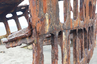
We camped at Fort Stevens state park
(love Oregon State Parks), where there was an old shipwreck on the
beach.
Moving down the Oregon coast, we stayed
with friends in Manzanita, Oregon, a quiet beachy town of 600 people.
Our friends have a beautiful home with ocean view. They toured us
through their favorite local spots and we gained a real appreciation
for how beautiful and rugged this part of the coast is.

We walked through old growth forest to a beach with massive driftwood.
 Octopus Tree
A very brisk storm came through, more typical of November weather. In about 50mph winds, Tom looked like
Albert Einstein when he came back from taking this picture.
By the next day, the air was scrubbed cleaned, and we had a wonderful beach walk. Not all creatures survived the storm so well.
From there, we made a bee-line, past Mt. Shasta, past abandoned homesteads, past northern California
farms amongst rolling brown hills, right to Becky, John and Junpier's house outside Reno. We have driven about 10,000 miles, but have traveled many more counting air flights and ferries.


We'll be here about 2 weeks, setting up
for the next 'Chapter'. More to follow after Sept 16.
Next Post: Chapter 2


 Octopus Tree


No comments:
Post a Comment