Devils Tower - Wyoming
Kris saw Devils Tower in 1991 when she took the kids cross country, but Tom was not on that leg of the trip. It was his turn to see this marvel.

The name Devil’s Tower comes from a mistaken translation of a conversation with a native speaker during a military expedition in 1875.

The view improved as we got closer.
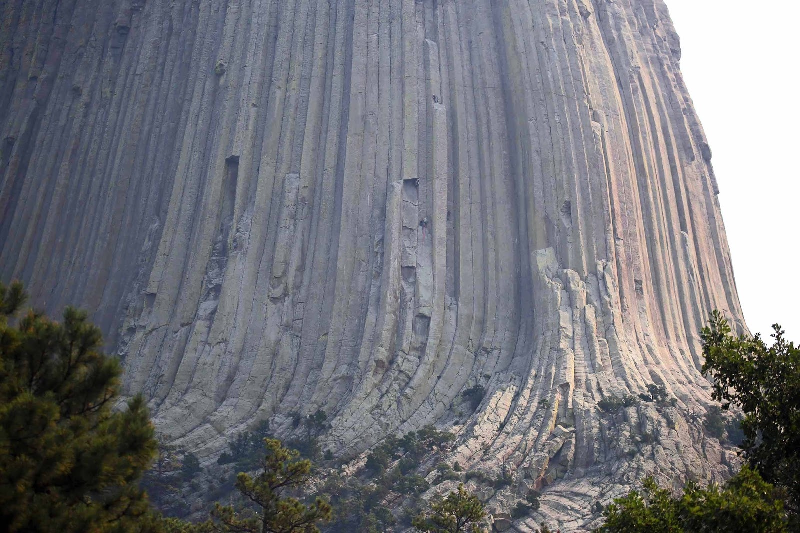
Devils Tower was the nation’s first national monument (different than a national park), so named in 1906. It was formed 50 million years ago when molten magma was trapped in the earth’s crust. It stands 865 feet from the base to the top. Approximately 1.5 vertical miles of rock and sediment have washed away since the tower formed. Geological estimates place the tower at greater than 50 million years old, although it is likely that erosion uncovered the formation only 1-2 million years ago.
 The native legend that explains the rock formation goes like
this: An Indian tribe was camped by the
river and seven girls were playing in the distance. A bear began to chase the girls and just
before the bear could catch them, the girls jumped up onto a rock and prayed to
the rock. The rock heard the girls’
prayers and elongated itself upwards, pushing the girls out of danger. The bear clawed on the sides of the rock as
it grew, attempting to reach the girls.
The claw marks explain the vertical parallel cracks.
The native legend that explains the rock formation goes like
this: An Indian tribe was camped by the
river and seven girls were playing in the distance. A bear began to chase the girls and just
before the bear could catch them, the girls jumped up onto a rock and prayed to
the rock. The rock heard the girls’
prayers and elongated itself upwards, pushing the girls out of danger. The bear clawed on the sides of the rock as
it grew, attempting to reach the girls.
The claw marks explain the vertical parallel cracks. 
This is a very popular climbing location.
The first known ascent was in 1893.
There are numerous climbing routes, ranging in difficulty.

We watched a climber reach the top, as well as others in progress, and spoke with a team that had just completed their assent. This is an activity to which neither of us aspires.


We walked the loop trail all the way around the rock. The trail brings you quite close to the start of a climbing area, where you get a feel for how imposing the rock is. The park rules are that anyone can free-climb the boulders surrounding the bottom of the rock, and a permit is required to climb any higher than the bolder field.

Moving out of Wyoming and into Montana, there is something for everyone .... almost. Rocks, rolling hills, 'big sky', but no water. It is very dry, partially explaining all the fires.


The grain silos are shaped a bit differently than home

Moving on to the next stop:
Little Bighorn Battlefield National Monument
 This turned out to be a very interesting site. It is somber, contemplative and interestingly
stark. The National Park Service and the
Craw nation collaborate to provide information about the events that took place
on this battlefield in 1876.
This turned out to be a very interesting site. It is somber, contemplative and interestingly
stark. The National Park Service and the
Craw nation collaborate to provide information about the events that took place
on this battlefield in 1876.  The battle,
known to the plains Indians as the Battle of the Greasy Grass, and to
non-native Americans as Custer’s Last Stand, was an overwhelming victory for
the native warriors, who were fighting for their very lifestyle.
The battle,
known to the plains Indians as the Battle of the Greasy Grass, and to
non-native Americans as Custer’s Last Stand, was an overwhelming victory for
the native warriors, who were fighting for their very lifestyle. The battle (particularly Custer’s actions) has been studied extensively.
 There is a mass grave with the re-interred remains of the
cavalry troops, but the more interesting markers throughout the battlefield are
the markers of where the soldiers fell.
The troops scattered about, and ended up fighting, and falling literally
back to back. Their markers are planted back to back
There is a mass grave with the re-interred remains of the
cavalry troops, but the more interesting markers throughout the battlefield are
the markers of where the soldiers fell.
The troops scattered about, and ended up fighting, and falling literally
back to back. Their markers are planted back to back The way that much of this
information became available was following a wildfire in 1983 that spread
across the battlefield. Following the
fire, many relics, bullets, and other materials became visible. Archeologists and forensic experts descended
on the facility and our park ranger described it as a ‘big CSI
investigation’. Quite a bit more was
learned about the positions of the troops, by the trajectory of the bullets
etc.
The way that much of this
information became available was following a wildfire in 1983 that spread
across the battlefield. Following the
fire, many relics, bullets, and other materials became visible. Archeologists and forensic experts descended
on the facility and our park ranger described it as a ‘big CSI
investigation’. Quite a bit more was
learned about the positions of the troops, by the trajectory of the bullets
etc. 
 There is even a grave for 39 horses. The soldiers would shoot their horse, then
use the dead animal as cover as there was no natural cover in the area. That
didn’t work very well ... for either party.
There is even a grave for 39 horses. The soldiers would shoot their horse, then
use the dead animal as cover as there was no natural cover in the area. That
didn’t work very well ... for either party.Indian descendants of the battle participants helped form the vision of the Indian Memorial.
The theme of the memorial is ‘Peace Through Unity”.
The seeds for peace and reconciliation were sown in 1926, when survivors and former adversaries gathered on the battlefield, shook hands, exchanged gifts, and politically buried the hatchet.

The memorial carries this sculpture, and many biographical profiles of the key Indian leaders and warriors that participated in the battle.
Moving on ....
We stopped for lunch in a random small town, parking in front of the post office. The whole town was a great example of rural Western architecture. Many small towns look like this:


Moving on to the next stop:
Lewis and Clark Interpretive Center
We learned some about the Lewis and Clark expedition in, possibly 4th grade, but not much since then, so this was a great stop to learn more about it. The 1806 expedition was an extraordinary feat as the first European explorers in the new territory. The primary purpose of their exploration was to locate a navigable route from the Missouri river to the Pacific Ocean, “The Great Northwest passage”.
It was a 28-month long expedition, taking 44 men who were chosen for specific mission critical skills. We got a kick out of the recruiting advertisement:
“Wanted: Healthy, robust, young men to explore Missouri River. Preferably unmarried. Special consideration given to boatmen, blacksmiths, gunsmiths and hunters. Must be willing to risk death. Salary $5 per month. Gentlemen’s sons need not apply.”
That wouldn't fly today!
Both Lewis and Clark kept extensive journals recording travel distances, navigational measurements, topographical data, ethnography, mineral and plant resources. Other men also kept diaries of the journey. As with most 19th century writers, they spelled words the way they sounded, with little concern for consistency. For example, Clark spelled “Sioux” 27 different ways, without ever spelling it correctly.
About 1600 miles into the trip, they set up a winter camp in what is now North Dakota, and recruited a 44-year-old French Canadian trapper, Toussaint Charbonneau, to serve as an interpreter. He brought along his pregnant 16-year-old wife, Sacagawea, who ultimately played a key role in the expedition as a translator, guide, and expert in back country survival.
One of the treacherous falls that were navigated (by portage), has now been dammed for hydroelectricity.

A short walk from the Lewis and Clark museum was the Giant Spring. This was a well-known site to the natives as the water temperature is a constant 54 degrees making it an ideal location for winter camps.
 Lewis and Clark documented
finding the springs in 1805. Geologists have determined that the water that flows here originates
about 400 feet below the surface.
Lewis and Clark documented
finding the springs in 1805. Geologists have determined that the water that flows here originates
about 400 feet below the surface. 
The overlying rock layers force the water upward through the overlying sandstone. It takes 50 years for water to flow from their origin (over 50 miles away) to these springs.

The water is so clean and so fresh, there are many aquatic plants that live in the water.
 Over 150 MILLION gallons of water flows through the springs … every DAY
… into the Missouri River.
Over 150 MILLION gallons of water flows through the springs … every DAY
… into the Missouri River. The Springs are now a State Park.
Cliff swallows nest in the area – they migrate enormous distances – ranging from Artic regions to the tip of South America.

More Montana - we saw miles and miles of it. It's a BIG state!


And onto the next Montana stop:
Pompey’s Pillar National Moinument
 This 150 foot tall pillar
is a massive sandstone outcropping that because of its geographical location
relative to Yellowstone River, it has been a celebrated landmark and
outstanding observation point for more than 11,000 years of human occupation.
This 150 foot tall pillar
is a massive sandstone outcropping that because of its geographical location
relative to Yellowstone River, it has been a celebrated landmark and
outstanding observation point for more than 11,000 years of human occupation. 
 It is also a bit of a journal of the American
west, as it has hundreds of petroglyphs, markings and signatures. The most notable visitor was Captain William Clark of the
Lewis and Clark expedition, who signed the pillar in 1806. His signature (protected now) is visible to
this day.
It is also a bit of a journal of the American
west, as it has hundreds of petroglyphs, markings and signatures. The most notable visitor was Captain William Clark of the
Lewis and Clark expedition, who signed the pillar in 1806. His signature (protected now) is visible to
this day.The tower was named by Captain Clark after Jean Baptists Charbonneau, the son of Sacagawea (native guide and translator who accompanied the Lewis and Clark Expedition), who Clark had nicknamed ‘Pompy’.
 There are now platforms and steps leading to the top where the view that Lewis, Clark and other explorers did see.
Within the national monument visitor center was a wonderful collection of original western art paintings by James Kenneth Ralston.
That was a wonderful bonus stop on our trip! Thank you H.T. and Carol for the recommendation.
And we keep driving across Montana with one more stop before Glacier National Park. Another frequent sighting while driving down the road, are abandoned homesteads. As part of the travel experience, we read books about and/or written by homesteaders and pioneers. The stories are interesting, and coupled with some of the poignant ‘broken dreams’ sights, make us think …

And then, there's always more rocks

And that brings us to the last stop before Glacier:
CM Russell Museum
No trip to Great Falls involving an art lover would be complete without a visit to the CM Russell Museum. There are over 2000 paintings and artifacts relating to CM Russell, as well as traveling exhibits of other artists who specialize in Western Art.


We have been following the news about wildfires in Glacier National Park with some concern. This was a high priority stop for us. For the third time in our married years we have tried to see Glacier and have been ‘weathered out’ each time. This is our third and possibly last try to see Glacier. Tomorrow’s plan is to drive to East Glacier where we are scheduled to pick up a rental car to tour the parts of the park that cannot be reached by motorhome. We'll see what tomorrow brings!
Night Night

Next post – Glacier National Park ... or not
We were just a little bit behind you guys. We were at Spirit Mound, the Badlands, Custer NBP, Devil's Tower and Pompeys Pillar as well among others. Carol counted the steps to the top there. After 254 each way we slept well that night.
ReplyDeleteCarol and H.T.
Tom & Kris,
ReplyDeleteLove your blog. Reminds us of the wonderful sights we've seen and yearn for those we've yet to visit.
Thanks and keep on posting.
Barb & Wes